From Risk to Resilience: Halff’s Texas Flood Warning Systems in Action
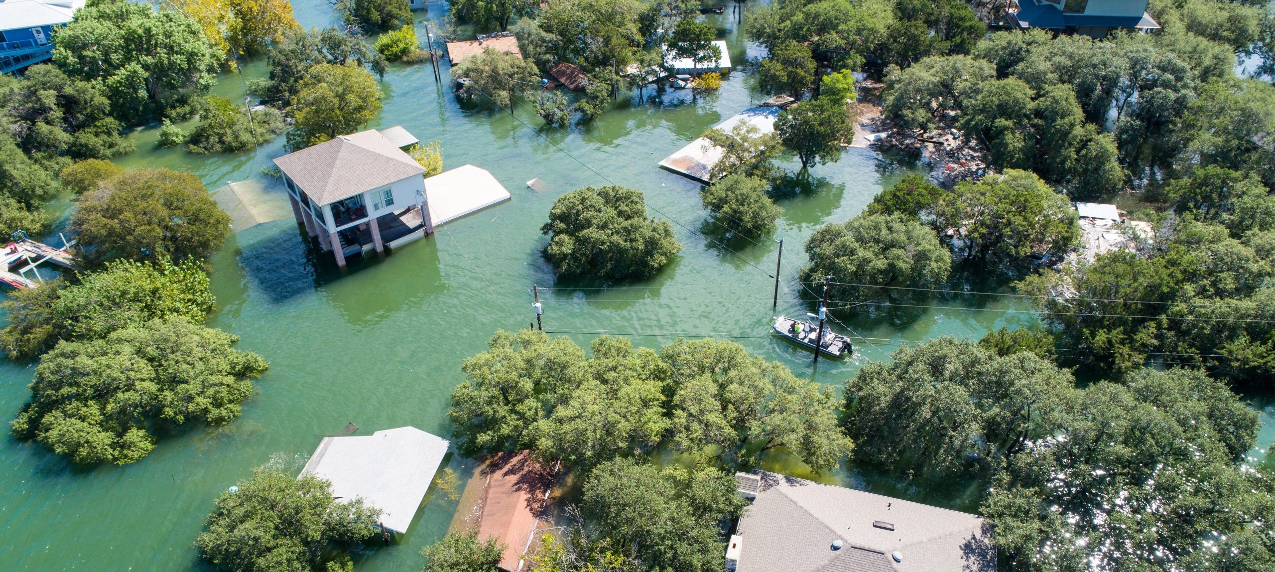
Many communities in Texas’ Flash Flood Alley face frequent heavy rainfall and severe flooding. In the aftermath of the catastrophic floods in Texas, implementing flood warning systems has emerged as a focal point for enhancing resilience through improved data sharing and public awareness.
Full flood mitigation can be extremely resource-intensive, both in terms of funding and implementation. Resilience relies on a mix of approaches such as smarter floodplain management, up-to-date risk assessments, targeted mitigation projects, public preparedness campaigns and improved warning systems. These systems empower communities to make informed decisions regarding flood risks. Not only does this matter for resilience, but for protecting precious lives and communities that are at stake during flood events.
Various flood warning options are available, including rainfall gages, stream and reservoir gages, cameras, signage, flashing lights, flood gates, alerts, messaging, sirens, real-time monitoring systems, flood inundation mapping tools, exposure identification tools, reservoir operation tools, flood forecast systems and more. These systems can be tailored to meet the specific needs of regional or local communities.
Seeing these needs only grow each year, investment in action is the way forward. That’s why Halff has supported the development of flood warning systems across Texas in collaboration with local and regional partners. The following examples illustrate how these efforts are being implemented to help communities prepare for future flood events.
Jump to Section:
Upper Brushy Creek | Hays County | Sugar Land | San Jacinto | Tarrant Regional Water District
Flood Monitoring Systems
Flood monitoring systems display real-time data (rainfall, gage data, cameras, etc.) and may include thresholds that prompt warnings, visualizations and actions. As a more economical option, they require less complexity and fewer personnel to operate. Monitoring systems offer information about current conditions, including those upstream, which can be useful for supporting quicker, more informed decisions during flood events.
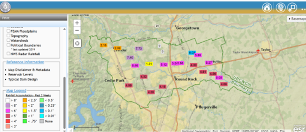
Upper Brushy Creek WCID Flood Monitoring System
The Upper Brushy Creek (UBC) Water Control and Improvement District (WCID) Flood Monitoring System includes reservoir gages, precipitation gages, stream gages, alerting systems and visualization tools. The UBCWCID Flood Monitoring Map displays real-time precipitation gage, stream gage, reservoir gage and radar data in combination with district reference data such as watershed boundaries, inundation easements, contours, dams and two layers that symbolize layers based on real-time gage readings. Live reservoir gages include a coloring symbology representing the recorded elevation relative to spillway elevations, indicating level of risk. Live precipitation gages include a coloring system representing the amount of rainfall over a user-specified duration.
This system has become a vital tool for both the District and the public, helping guide timely flood response decisions and increasing community awareness during severe weather events.
This live information is used by the public and UBCWCID to prepare for potential flood events.
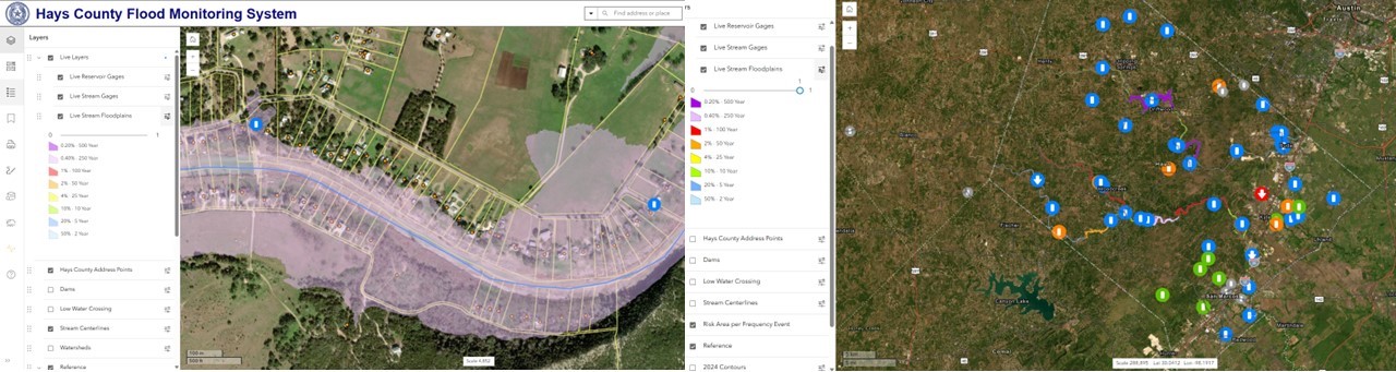
Hays County Flood Monitoring System
The Hays County Flood Monitoring System (FMS), which aids local flood response and resilience efforts, represents a key advancement in flood risk management. The FMS includes:
-
-
- 10 reservoir gages
- 27 low water crossing stream gages
- 20 precipitation gages
- 8 low water crossing cameras
- Flashing signage, alerting systems and sirens
- Visualization tools
-
The Hays County FMS uses a secure web-map for emergency personnel that displays a real-time rainfall gage, stream gage, reservoir gage and radar data in combination with Hays County reference data, which includes boundaries (parcels, precincts, municipalities, ETJs and emergency services), 911 address points, risk areas, contours, best available static floodplains, dam breach floodplains and FEMA floodplains.
The site includes three automated (live) layers that symbolize layers based on real-time gage readings. Live reservoir gages also include a coloring symbology representing the recorded elevation relative to spillway elevations indicating the level of risk. Live low water crossing stream gages display a coloring symbology representing the recorded elevation relative to roadway elevations, indicating if water levels are near or over the road.
In addition to the symbology color, the last three reported stage readings for reservoirs and crossings are utilized to indicate if the stage is rising, static or falling. Live floodplains automatically display inundation floodplains based on stream stage.
The Hays County FMS stands out as not just a technical achievement; it’s a tailored, real-time decision support tool empowering emergency responders and the community. By combining local data and advanced visuals, Halff delivered a solution that’s actively helping communities respond effectively to flood risks.
These automated (live) floodplains provide visualization of estimated flood inundation extents and impacted structures for selected streams in the county.
Sugar Land
Halff developed the City of Sugar Land Integrated Stormwater Management Model (ISWMM) to improve flood risk awareness, stormwater management and real-time data access. The multi-phase approach of ISWMM’s development started with a focus on
data collection and organization, compiling available hydrologic and hydraulic models, reports and GIS datasets to establish a structured database. This required integrating storm sewer layers, ponding maps and spatial data critical for stormwater planning. The GIS framework provided a foundation for subsequent analysis and modeling efforts.
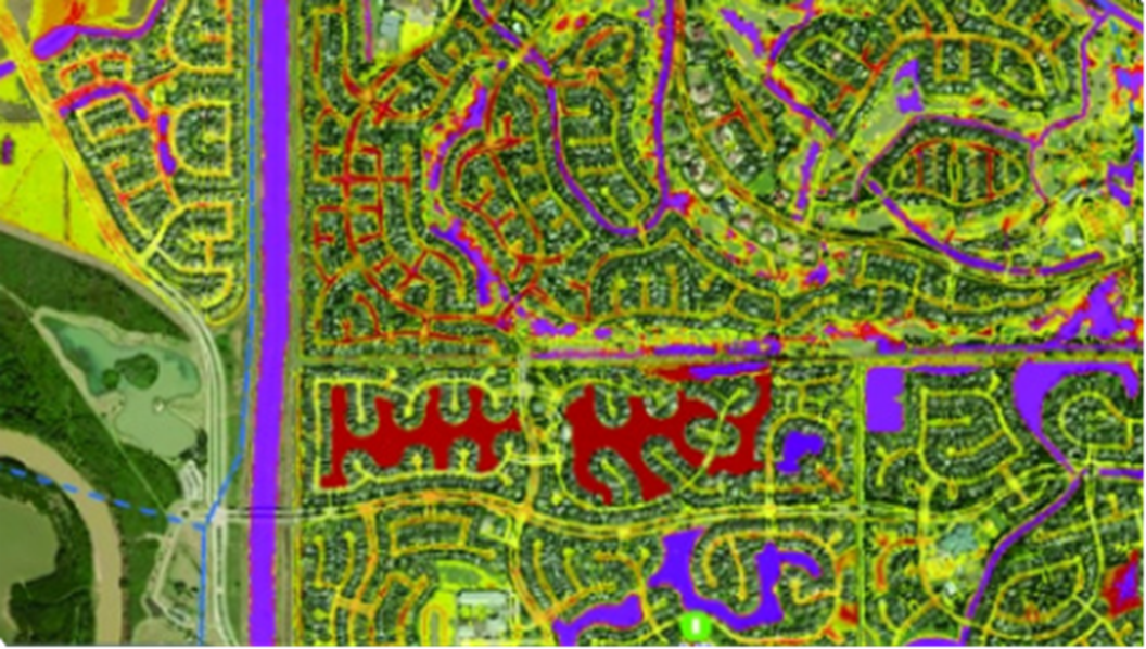
Halff advanced the City’s flood risk assessment by generating citywide ponding maps for 2- through 500-year Atlas 14 storm events using detailed 2D hydraulic modeling and rain-on-grid simulations. Additionally, a levee breach simulation modeled drainage system responses, flood progression and impacts on critical infrastructure, assisting the City in emergency preparedness and response planning.
Halff integrated real-time data from 27 rain and stream gages throughout the city, feeding directly into a public facing web-based mapping platform. This system continuously updates cataloged ponding maps and provides instant alerts on street flooding. Potential closures are also shown, based on live rainfall and stream conditions. Rain gage symbology was tied to real-time stream levels, giving city officials and residents accessible, up-to-the-minute flood risk information.
ISWMM now serves as a key tool for flood monitoring, emergency planning and long-term stormwater infrastructure improvements. This equips the City of Sugar Land with reliable, real-time data for decision-making and public safety.
Sugar Land’s ISWMM was recognized with the 2023 ACEC Texas Engineering Excellence Silver Award.
Flood Forecast Systems
Flood forecast systems display both flood monitoring data and predictive data. Forecast systems generally incorporate analysis and modeling to predict future conditions, and may include predictive thresholds that prompt warnings, visualizations and actions. Due to their advanced features and need for skilled operators, these systems can be more expensive, but they support more proactive responses.
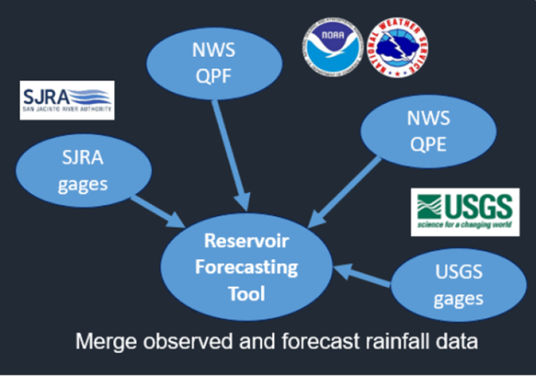
San Jacinto River Authority
Halff was contracted by the San Jacinto River Authority (SJRA) to develop a real-time Lake Conroe reservoir forecasting tool to be used by SJRA to inform lake level analysis as needed during storm events. Lake Conroe covers a surface area of approximately 20,000 acres and has a watershed of 450 square miles. The forecasting tool leverages the following available real-time hydrometeorological data for the Lake Conroe watershed:
-
-
- Quantitative Precipitation Estimates (QPE) gridded rainfall
- Quantitative Precipitation Forecast (QPF) gridded rainfall
- Rainfall gage data
- USGS reservoir level (Lake Conroe Dam)
- USGS streamflow data
-
This tool collects radar, rain gage and National Weather Service rainfall data, then combines actual and predicted rainfall to forecast reservoir inflows using computer models. The calculated inflows based on actual and predicted rainfall are used to estimate potential releases from the lake. This information is useful to SJRA in analyzing levels and coordinating potential releases with local emergency management officials.
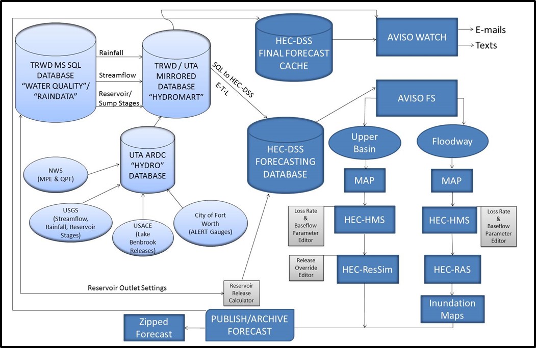
Tarrant Regional Water District
Halff facilitated the development of a flood operations decision support system for Tarrant Regional Water District (TRWD) for the Upper West Fork Trinity River Basin. The Upper Trinity River Flood Operations Decision Support System (UTRFO-DSS) included the development of calibrated computer models. These models were integrated into the customized tool to provide real-time data viewing and decision support by seamlessly linking real-time data feeds with the inputs and outputs of each of the models.
In addition to the hydrologic, hydraulic and reservoir operations components, the UTRFO-DSS included a mean areal precipitation viewer, inundation mapping viewer, and customized editors to allow users to interact with the modeling software and databases. The tool also includes recognition and warning application features to generate automated alerts when observed and forecasted threshold values are exceeded.
Halff’s trusted Water Resources team is here to help. We understand the urgent challenges that flooding poses to communities, requiring solutions that truly fit. With more than 75 years of collective experience working across Texas, we recognize that flood resilience is not a one-size-fits-all approach. Every watershed has its own characteristics, flow patterns and risk factors. That’s why we work closely with each community to develop strategies that are grounded in local conditions, informed by data and built for long-term impact.
Partner with Halff by contacting Water Resources Practice Leader Sam Hinojosa, PE, CFM (shinojosa@halff.com) or Water Solutions Leader Cindy Engelhardt, PE, CFM (cengelhardt@halff.com).

Recent Stories

Gravel Ridge and FSM Aircraft Arresting System Awarded Gold by ACEC Arkansas
LITTLE ROCK, Ark. — Three Halff projects collected 2026 American Council of Engineering Companies (ACEC) Arkansas Engineering Excellence Awards (EEA)….

Past to Present: The Importance of Surveying
In celebration of National Surveyors Week, we take time to commemorate some of the most interesting aspects of land surveying’s…